.png)

Geospatial Services Built for
Real Project Data

Drone Imagery Processing & Deliverable Prep
Already have drone imagery or site data collected? GIS Guys helps clean, organize, review, and prepare that data so it can be used for project reporting, planning, measurements, and decision-making.

Review drone imagery, orthomosaics, and site files for usability, coverage, and project readiness.
Prepare clean map exhibits, overlays, labels, boundaries, and visual outputs for reports or presentations.
Export deliverables in formats your team can use, including PDFs, shapefiles, DXF files, web maps, or GIS-ready layers.
Project-Ready
Clean deliverables from raw site data


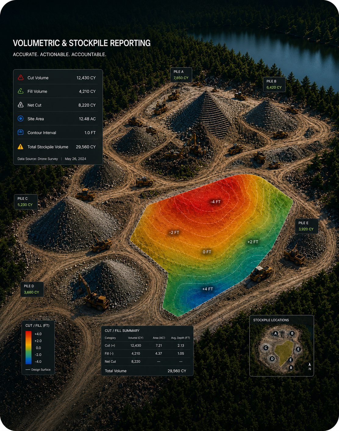
Volumetric & Stockpile Reporting
Turn drone, LiDAR, and elevation data into measurable quantities your team can use for inventory tracking, earthwork updates, and project reporting.
Calculate stockpile volumes, material quantities, and cubic yard summaries from surface or elevation data.
Define pile boundaries, compare surfaces, and organize measurements into clean report-ready outputs.
Deliver quantity tables, map exhibits, contour visuals, and PDF reports your team can share with clients or project managers.
Volume-Ready
Clear quantity reports from site data


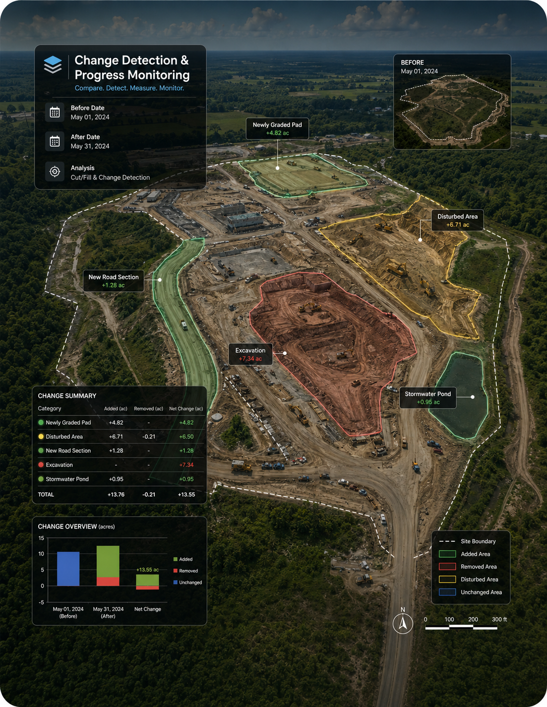
Change Detection & Progress Monitoring
Compare drone, LiDAR, CAD, or GIS datasets over time to identify meaningful site changes, document progress, and keep project teams aligned.
Detect cleared areas, disturbed land, new work zones, grading changes, and updated site conditions.
Create before-and-after maps, change polygons, acreage summaries, and visual progress exhibits.
Turn recurring site data into clear progress reports your team can share with clients, contractors, or leadership.
Change-Ready
Progress maps from repeat site data

LiDAR & Elevation Analysis
Process LiDAR, point clouds, DSMs, DEMs, and elevation surfaces into usable terrain insights for mapping, measurement, and site analysis.
Review elevation data, terrain models, and surface outputs for project accuracy and usability.
Create contours, elevation visuals, slope maps, surface comparisons, and terrain-based exhibits.
Prepare GIS-ready elevation deliverables for planning, reporting, volumetrics, and construction analysis.
Terrain-Ready
Elevation insights from LiDAR and surface data

Our Guarantee
Our Pledge To Our Clients
We guarantee a transformative and empowering journey with our GIS services. Consider us your personal geospatial concierge, smoothly navigating you through complex data to enhance your capabilities and exceed your project goals.

Consultation
Dive into a pool of wisdom with our expert consults, where every question leads to deeper understanding and solutions.

Seamless payments
Smooth sailing ahead! Our payment process is as easy as pie—sweet, straightforward, and always on your terms.
Lower your costs
Stretch your dollars further without stretching your team thin. We make cost-efficiency a thrilling chase for value.
Why Choose
GIS Guys?
Customized Solutions

Receive personalized GIS strategies tailored to meet the specific needs of your business or academic project.
Dedicated Support

Enjoy comprehensive support throughout your project, with easy access to our experts who are committed to your success.
Proven Track Record

Join a long list of satisfied clients who have achieved enhanced efficiency and productivity through our proven GIS solutions and dedicated service.
Our Guarantee
Geospatial Precision Promise
We stand behind our Geospatial Precision Promise, guaranteeing top-tier accuracy and clarity in every service, from map creation to data analysis. Trust us to deliver you unparalleled precision.

We transform complex data into clear, actionable visuals that make patterns and predictions easily understandable.

Our maps are meticulously crafted, ensuring exact geographical representation for reliable analysis & navigation.

Innovative Spatial Analysis, leverage our cutting-edge spatial analysis techniques to optimize your spatial strategies.
Frequently Asked Questions
Do you fly drones or collect aerial imagery?

GIS Guys focuses on processing and analyzing drone imagery, LiDAR, CAD files, and GIS data that clients already have. We do not currently position ourselves as a drone flight provider. If you need new drone data collected, we can help you understand what type of imagery, accuracy, overlap, control points, and deliverables to request from your drone pilot or data provider. We can also put you in touch with an excellent drone team to help you fly your sites.
What kind of drone data can you work with?
We can work with drone photos, orthomosaics, DSMs, DEMs, point clouds, LiDAR datasets, CAD files, shapefiles, geodatabases, PDFs, and other common geospatial formats. If you are unsure whether your files are usable, send us the data details and we can review the best path forward.
Can you calculate stockpile volumes?
Yes. GIS Guys can calculate stockpile volumes, material quantities, pile boundaries, cubic yard summaries, and quantity changes using drone, LiDAR, surface, or elevation data. Final accuracy depends on the quality of the source data, ground control, coordinate system, surface model, and site conditions.
Can you compare two drone flights and show what changed?
Yes. We can compare datasets from different dates to identify meaningful site changes, disturbed areas, cleared land, new work zones, grading changes, and progress boundaries. Deliverables can include change maps, polygons, acreage summaries, shapefiles, PDFs, and visual reports.
Do you provide survey-grade results?
GIS Guys provides geospatial analysis, mapping, reporting, and decision-support deliverables. We do not represent our work as a replacement for a licensed survey unless a licensed surveyor is involved. For projects requiring stamped survey-grade results, legal boundaries, or certified measurements, clients should consult a licensed survey professional.
How long does a typical project take?
Small mapping or review projects may take a few business days. Larger projects involving volumetrics, LiDAR, change detection, dashboards, or multiple deliverables may take a week or longer depending on file size, data quality, site complexity, and the requested outputs.
Ready to Turn Site Data Into Answers?
Send your project details and we’ll recommend the best path forward.


